Waves:
- Low pressure systems (indicated by an "L") are what produce waves.
- Imagine someone threw a rock in the water right in the middle of the low, and the waves will come from the centre out.
- The closer the lines (isobars), as well as the number of isobars around the low, the bigger the rock and thus, the bigger the waves.
- The distance of the low pressure system to Maroubra affects when they will arrive, and their size:
- The bigger the wave is, the faster it will travel, generally, they don't travel that quickly.
- Waves get smaller the further they have to travel.
Wind:
- Wind travels along the isobars that are around the low and high pressure systems.
- The closer the lines are, the faster the wind goes.
- Wind goes around the low pressure system clockwise, and anti clockwise around the high pressure system.
Putting it all together:
Waves:
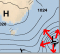
- The low in the bottom right will produce waves.
- The waves will travel to Maroubra from the South East (SE). Therefore, you say it will be a SE swell.
- The lines (isobars) around the low are fairly close together, however, there aren't many isobars around the low, so the waves at the low will probably be around 6 foot.
- The Low is a fair distance away from Maroubra, so it will take about 1 or 2 days for the swell to reach Maroubra.
- By the time they get here, they will have lost a lot of their energy, so they will be around 3 feet.
Wind:
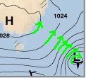
- The lines (isobars) over Maroubra travel from a South West (SW) direction (remember wind goes anti-clockwise around a high, and clockwise around a low). So you would say there is a SW wind.
- The lines (isobars) are far apart, so there would be very little wind.
- Remember that the waves won't arrive for another 2 days, so you would actually look at the forecast synoptic chart for 2 days in advance to work out the wind.
Where to find a synoptic chart:
DONE!
Too easy right!? ...well
Pressure system movement - High pressure is the bully:
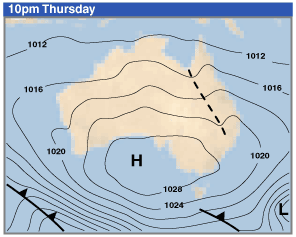
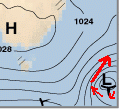
- You may remember from high school, that high pressure moves towards low pressure to even out the pressure difference. That means the high will move over to our wave producing Low and beat it until it's dead. The smaller the low and/or the bigger the high, the faster we will lose our waves. We can see this by looking at the forecast charts:
-
From this ...
-
...going
-
...gone
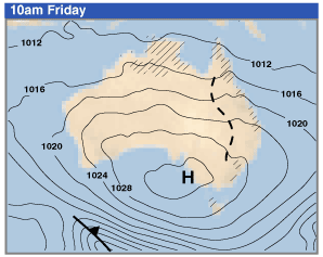
- So when we have this information, we can see the Low pressure system will be killed off in less then 24 hours (that's fast!), so the waves the Low produces are not going to last long at all. And we would want to revise our estimate of 3 feet of swell arriving in 1 or 2 days, to 1 or 2 feet of swell popping in for a quick schooner (know as a "pulse" of swell).
Summer time - Sea Breezes:
- In the summer, we get northeast (NE) sea breezes (if you care why, you can read all about it here Sea Breeze).
- These sea breezes are not shown on the synoptic charts, however, they produce a localised messy wind swell, and mess up any ground swell (the swell created by low pressure systems).
- The hotter the day, the stronger the NE wind.
Wave period - The longer the stronger:
- A wave period is the distance between the waves (Eg: A 12 second period will mean 12 seconds will pass before the next wave).
- Waves created by a low pressure system will have a long wave period.
- Waves created by a sea breeze will have a short wave period.
- Waves with a long period will have more power then waves with a short period.
- Basically, the longer a wave travels, the longer the period gets (but don't forget the wave size will also drop the further it travels).
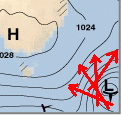
Waves - The rock in the ocean theory:
-
So you know waves are generated by wind. So why do they come out from the centre of a low pressure system? OK, you got me, they actually don't. It's more like this:
You can see that the wind circles around the low, however, waves can't go around in a circle (unless they hit something), so they go straight out from the low.
- You can also see that the lows isobars are more intense (lines are closer together) on the top left, then on the bottom right.
- This mean that the swell generated from the low, will be stronger travelling out from a Northeast direction, then they will be from a Southwest direction.
- The direction we care about, swell travelling in a Northwest direction (referrer to as a Southeast swell), will be middle of the road.
- Meaning that 1 or 2 foot swell pulse we were expecting, my not even eventuate.
If you understood all that, you'll know why Bali gets some of the best waves in the world. Here's why:
- Intense Low pressure systems form in the wild weather of the Antarctic.
- The massive swells that are produced by these Lows have a clean run from west of Perth, straight up the Indian Ocean to near the equator.
- Bali, sits right near the equator where the weather is calm. Winds are usually light.
- The distance from where the Lows form, to Bali is huge, with nothing in the way. The waves will take about a week to travel that distance.
- Because the waves have to travel so far, their period increases, giving them more power, however, their size drops, making them more manageable to ride.
- Surf forecasting is a breeze, as you can literally see the waves on their way.
- Not to mention Bali is a volcanic region, with steep long reefs that form near perfect waves over and over again (as long as you have some surfing experience - not so perfect for a beginner).
- So Bali gets waves that are predictable, have power, and are clean (due to the light winds). It's what dreams are made of!
That'll do pig... that'll do.